Due to our messages being only 50 baud, the payload could only send down one telemetry string every 15 seconds. Therefore it may have originally looked as if our highest altitude was infact 33,116m, from message 10140. However having recovered the payload we’ve got the second-by-second GPS log back, and here is the log of the burst!
$$A1,10145,14:11:22,52.237948,000.520583,33150,0000,09,2A412A32,45*6D   | 14:11:22: N52.237948 E000.520583 33150M (09 satellites), Internal:  32.5'C, External:  25.0'C

$$A1,10146,14:11:23,52.237980,000.520791,33156,0000,10,2A412A32,45*64   | 14:11:23: N52.237980 E000.520791 33156M (10 satellites), Internal:  32.5'C, External:  25.0'C

$$A1,10147,14:11:24,52.238000,000.520976,33158,0000,09,2A412A32,45*6D   | 14:11:24: N52.238000 E000.520976 33158M (09 satellites), Internal:  32.5'C, External:  25.0'C

$$A1,10148,14:11:25,52.238026,000.521156,33155,0000,09,2A412A32,45*61   | 14:11:25: N52.238026 E000.521156 33155M (09 satellites), Internal:  32.5'C, External:  25.0'C

$$A1,10149,14:11:26,52.238075,000.521343,33147,0000,09,2A412A32,45*60   | 14:11:26: N52.238075 E000.521343 33147M (09 satellites), Internal:  32.5'C, External:  25.0'C
Giving us a highest achieved altitude of 33.158KM: which is (at the time of blogging) third place in the UKHAS UK Records.
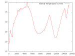
Furthermore, the full flight logs from power on to landing are available here, decoded & annotated here, and gnuplot graphs of various metrics are available below.
-

-
ALIEN-1: Altitude vs Time
-
-
ALIEN-1: Internal Temperature vs Time
-

-
ALIEN-1: External Temperature vs Time
-

-
ALIEN-1: External Temperature vs Altitude


